
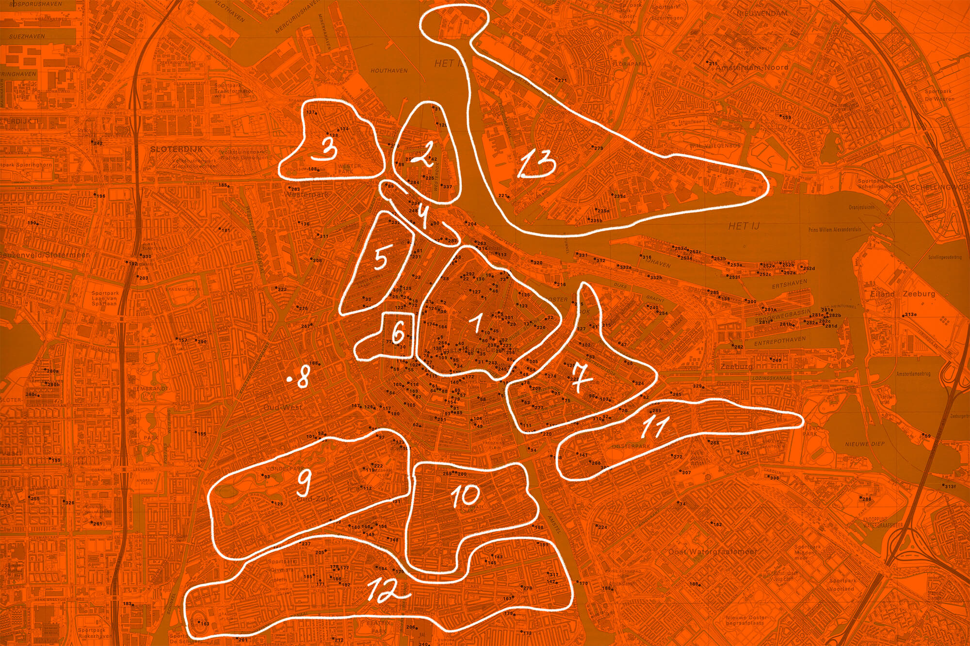
1. Old Center
Where it all began: a dam across the Amstel around 1270 — the city is literally named after it. Everything here stands on wooden piles driven through peat, and the medieval street plan still reads clearly: Oudezijds and Nieuwezijds, old side and new side of a river that no longer shows. From April to October it's properly crowded, so we mostly pass through — for a film at the century-old Tuschinski, the bookstores on Spui, and the world's first large underwater bicycle garage by Centraal.
2. Westelijke Eilanden
Three artificial islands — Bickerseiland, Prinseneiland, Realeneiland — raised from the IJ around 1615 for the dirty, flammable trades: shipyards, tar boilers, herring packers. The warehouses still say what they stored. Artists moved in when the port moved out, and it became a village in the heart of the city — our favourite district, and our home. Almost no cafés, but two swimming spots and the Silodam block with its terrace over the IJ.
3. Westerpark & Spaarndammerbuurt
The city's 19th-century industrial back door: the Westergasfabriek lit Amsterdam's streetlamps from 1885, poisoned its own ground doing it, and reopened in 2003 as a culture park — the old gas holder is now a concert hall, the sumps are reed lakes with herons. Across the tracks, Het Schip (1919–21) is Michel de Klerk's 'workers' palace' — social housing built like a cathedral, the high point of the Amsterdam School.
4. Haarlemmerstraat
The medieval dike road to Haarlem — for centuries the only dry way west. The West-Indisch Huis halfway along is where the West India Company decided, in 1625, to build a fort on Manhattan; New York was administered from this street. Today it's one of the city's best shopping runs: Number Nine, Kaasland, the games store Het Paard, a Wednesday farmers' market, and The Movies, in business since 1912.
5. Jordaan
Built in the 1610s expansion for workers and immigrants — which is why its streets ignore the canal grid: they follow the old polder ditches, angled against everything. By the 19th century it packed in 80,000 people and was the city's poorest quarter; now it's the most romanticized. The charity courtyards (hofjes) are the layer we love — slip into Hofje van Brienen. Then wood-fired pizza at La Perla, Café 't Smalle on the canal, apple pie at Winkel 43.
6. Negen Straatjes
The nine cross-streets stitching the canal belt together — the 1610s Grachtengordel, on the UNESCO list since 2010. The names are the old leather trade: Huidenstraat for hides, Runstraat for tanbark. Big brands have pushed out most of the indie shops, but Marie-Stella-Maris, Misc and From Here To Tokyo hold the line, and our favourite Japanese restaurants hide here.
7. Plantage
The expansion of 1663 was too ambitious — the city stopped growing, and these plots stood empty for 200 years as rented pleasure gardens; the name means exactly what it says. That accident gave the quarter its greenery: the Hortus Botanicus (1638, one of the oldest botanical gardens in the world — we go for breakfast on sunny days) and Artis (1838, the oldest zoo on the continent). Skip the ticket: coffee on Artisplein comes with flamingos in the canal.
8. De Hallen
Oud-West went up fast in the speculative 1880s, and the electric tram got its depot here in 1902 — a long iron shed that outlived the trams and reopened in 2014 as a food hall, cinema and small shops. We come on grey days, then walk out to Bellamyplein — one of the cosiest little squares around — past Dak Showroom, gelato at Massimo in hand.
9. Vondelpark & Oud Zuid
Vondelpark (1865) wasn't a city project — wealthy citizens paid for an English landscape park at their new front doors, and the city grew around it. It's laid on peat and has been sinking ever since; the trees stand on rafts, and every generation raises the paths again. When it's sunny, the whole city is here. Museumplein next door got the Rijksmuseum in 1885 and the Concertgebouw in 1888 — we mostly go to the Stedelijk.
10. De Pijp
The first speculative expansion after the canal ring, thrown up in the 1870s on filled polder ditches — the long, pipe-narrow streets follow them exactly, and the jerry-building was so bad a few houses collapsed before they were finished. Built cheap for workers, now hip and dense. Sarphatipark honours Samuel Sarphati, the doctor who dreamed the modern city; the Albert Cuyp market has run since 1905.
11. Oost
Colonial money built this side of town: the Indische Buurt's streets are named for Java, Sumatra, Borneo — the empire the port lived off. Oosterpark (1891) was the first park the municipality laid out itself, not the merchants. History answered the street names: Javastraat is now the most multicultural street we know — Surinamese, Indonesian, Turkish, Moroccan. Around Andreas Bonnstraat the fashion-academy crowd keeps Yusu and Taigu busy; weekends we pick up exotic fruit at the Dappermarkt.
12. Nieuw Pijp & Oud Zuid
Plan Zuid (1917) was Berlage's answer to De Pijp — the first great masterplan under the 1901 Housing Act, when the city decided workers deserved architecture too. The result is the Amsterdam School at full power: sculpted brick, monumental streets, space and light as policy. Find the symmetrical square around De Dageraad (1920–23, De Klerk and Kramer) — social housing as a monument, with a small museum about exactly that.
13. Noord
The other bank: shipyard land, where NDSM built some of the biggest ships in the world until the yards died in 1984. The free ferries exist because the city never built a bridge — and still hasn't. In the 1920s Noord got garden villages for workers, built on garden-city ideals; now the empty slipways carry studios, the STRAAT graffiti museum, Europe's largest flea market once a month, and the Kraanspoor — a harbour crane runway turned office.
Most of the spatial history here we owe to Fred Feddes’ A Millennium of Amsterdam — the best book about how this city was made. Thanks to our favourite shop, Architectura & Natura for this book recommendation.